Phipps Stories

#bioPGH Blog: A Crash Course into Weather
 A resource of Biophilia: Pittsburgh, #bioPGH is a weekly blog and social media series that aims to encourage both children and adults to reconnect with nature and enjoy what each of our distinctive seasons has to offer.
Last week’s winter storm was 2,200-mile long mass of a weather system that dropped ice, sleet, rain, and snow on different parts of the country as it traveled. Multiple meteorologists noted the “winter lasagna” some regions received, with alternating layers of ice, snow, slush, and ice making a crunchy, messy situation while other regions received sheets of ice that pulled down powerlines and heavy tree branches.
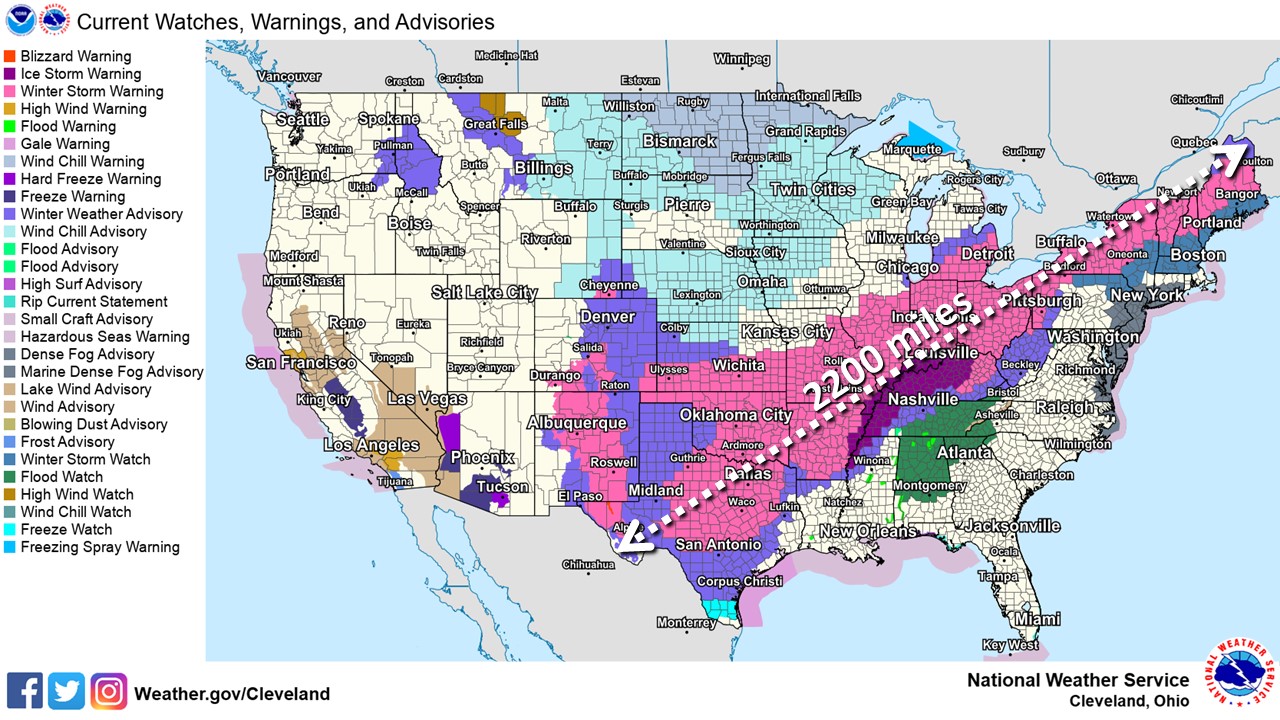
Image: National Weather Service, Cleveland Office
What could cause a storm that size? Is that normal within weather patterns — and what exactly is weather anyway? Why does it rain one day but then give us blue skies the next day? Let’s take a look at what makes weather! As a quick note, I do want to emphasize that we are talking about weather, not climate. Weather describes the conditions at any single given time, but climate considers weather patterns over extended periods of time. We can think of weather as deciding if you need to bring an umbrella to work with you in the morning, while climate is deciding what to pack for a Florida vacation in July or an Alaskan vacation in January.
Let’s start by taking a huge step back from Western Pennsylvania and our local weather, and instead look at the planet as a whole. As the Earth rotates on its axis around the sun, the heat from the sun ultimately generates huge currents of air called cells. In each the Northern and the Southern Hemisphere, there are three cells: the Hadley Cell, Mid-Latitude Cell, and Polar Cell. These circulating currents of air are powered by the difference in temperature between the poles and the sunny equator. As the warm air rises, it fills the space left behind by cooler air from the poles falling (for my fellow bakers out there, this is exactly like air movement in a convection oven). This creates huge currents of air all around the planet, and these circulation patterns are ultimately responsible for the planet’s major winds like the trade winds and the “rivers of air” known as the jet streams.
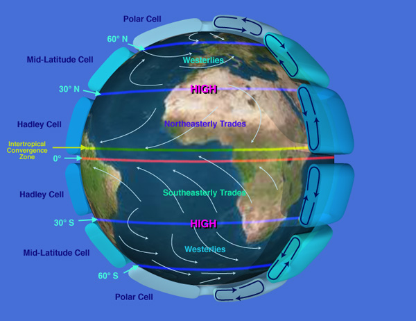
Image: NASA
And those jet streams are exactly what we are going to look at next. In broad terms, jet streams are “rivers of air,” or fast-moving winds, that wrap around the globe and separate cold air masses from warm ones. Our polar jet stream is the boundary between the cold air around the Arctic and the warmer air coming from the south or equatorial regions. In the image below, you can see a generalized idea of where the jet streams sit relative to the air circulation cells we looked at above.
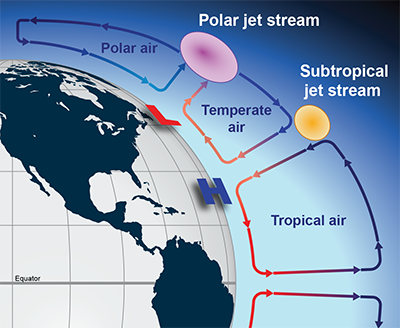
Image credit: National Weather Service
The “river of air” doesn’t follow a single path around the globe; it weaves north and south, constantly moving, bringing weather fluctuations along with it. In the NASA video below, you can get an idea of the how the “river of air” travels around the globe. The animation below reflects thirty days of jet stream activity.
So now that we have a basis for air movement around the planet, we can zoom in a bit more close to home to look for the interplay of global and local: what causes the weather patterns we see every day? In short, it’s a complicated answer that includes moisture in the air, temperature, winds, clouds; but these are all closely tied in to changes in air pressure. Air pressure (you may have also heard it called atmospheric pressure) is literally the density of molecules in the air. When mountain climbers struggle to breathe at high altitudes because of low oxygen, they are experiencing very low pressure — the density of oxygen molecules is so low, their body can’t function properly.
The air pressure makes a world of difference for what weather we can expect each day. When the atmospheric pressure is low, that means air molecules are not tightly packed in and, thus, other things like clouds can rush in to fill the empty space in the center of a low pressure system. (Kind of like…if you are at a crowded concert, it is energetically easier for you to walk into the open space at the back of the room than it is to smash into the dense crowd by the stage.) As air and water vapor move into that low pressure space, we feel the resulting wind and cloud formations. High pressure days (days where the atmospheric pressure is already higher) tend be calm and cloud-free as air and water vapor won’t easily make its way into a high-pressure space.
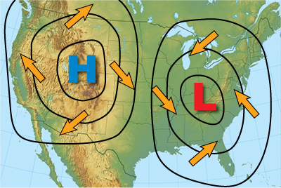
Image: National Weather Service
You’ve probably also heard of warm and cold fronts as major factors in weather. A front is technically the boundary of the cold or warm weather system, which are cold masses of air and warm masses of air, respectively. Masses of air are quite literally what they sound like – a large volume of air that can be cool or warm and have some degree of humidity. These masses tend to form over an area like the ocean or an expanse of land, and the mass will acquire traits from where it formed (e.g. a warm, humid mass may have formed over the ocean, a cold mass may have developed over Canada). Cold fronts tend to be associated with low pressure systems while warm front tend to be associated with high pressure systems (think of the sudden cool air right before a thunderstorm).
Here is where the jet streams become so important. The jet stream’s activity can influence cold or warm weather systems by either moving them across the US or leaving them in place. In the case of the winter storm we saw this past weekend, the jet stream was dipped far south into the US, bringing Arctic air with it. This combined with a cold front system, and the jet stream carried them diagonally across the eastern half of the United States.
This all was complicated already. Traveling air masses, global wind currents generated by the heat of the sun, water vapor moving into new spaces and creating clouds — weather is all physics! And we only scratched the surface of the topics mentioned so far. But other factors also influence daily experiences of weather. Topography, for example, hugely impacts what kinds of weather an area can expect to see. Is the local land expansive and flat? Allowing air to rush through as the pressure changes? Or is your area hilly or even mountainous? Creating barriers for weather systems as air masses attempt to move about the surface of the planet? Are you near an ocean, which can allow weather systems to pick up moisture from the sea as they travel? Are you near the equator? With sunlight constantly energizing molecules in the air around you? And we haven’t even mentioned the influence of seasons (the Earth’s tilt) on daily weather! Or the link between climate, Arctic sea ice and the jet stream. Whew!
All of this is to say — when we experience weather, there are so many natural processes at work and we hardly notice them. Nature is full of surprises and hidden secrets; there is always plenty to learn. In the meantime, let’s high five our local meteorologists the next time we see them. What a tough job!
Connecting to the Outdoors Tip: You don’t have to be a meterologist to record weather data! If you have the space for a rain gauge, you can keep one outside your home and measure rainfall yourself. Or, you can find a USGS rain gauge near you and keep track of data from somewhere nearby. For a deep dive, NOAA also has decades of climate and weather data available online, and it can even graph itself! The easiest way to look at long-term climate data is through the Climate at a Glance tool. You can review a century’s worth of data on temperature, precipitation, maximum temperatures, minimum temperatures, etc. for every state.
Continue the Conversation: Share your nature discoveries with our community by posting to Twitter and Instagram with hashtag #bioPGH, and R.S.V.P. to attend our next Biophilia: Pittsburgh meeting.
Resources
National Geographic – Atmospheric Pressure
Image credits: Header and cover, Pexels; all other images public domain with their federal agencies noted.


